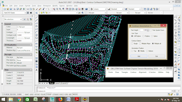
Today we are discussing about best contour software to generate best contour line in autocad. All software are free version or you can easily download crack version from many others website.

Best Contour Softwares | Best Contouring Products.
Contour Line, The Line of intersection of a level surface with the ground surface is known as a contour line . It can also be defined as a line passing through point of equal reduced level . The general map of country includes the location of roads , river , village railway , pond/water logged , village, town , survey plot number and so on , but the nature of ground surface cannot be realized from such a map . However for all engineering project involving road ,railway,inauguration project and so on , a knowledge of nature ground surface is required for locating suitable alignments and estimating the volume of earth work . Therefore the contour map is essential for all above engineering project . This is why the contour map are prepared.Use of Contour Map :-
According to the N N Bashak
the following are the specific use of contour map :
- The nature of ground surface of a country can be understood by studying a contour map. Hence the possabe route of communication between different place can be demarcated.
- A suitable site or an economical alignment can be selected for any engineering project.
- The capacity of a reservoir or the area of a catchment can be approximately computed.
- The intervisibility or otherwise of different point can be established.
- The Suitable route for a given gradient can be marked on the map .
- A section of ground surface can be drawn in any direction from the contour map .
- Quantities of earth work can be approximately computed .
Today we are discussing about best contour software to
generate best contour in autocad.All software is a free version or you can
easily download crack version from many
others website.
We will compare between below Software:-
- Contour by SW DTM Software.
- Contour by Surfer Software.
- Contour by AutoPlotter Software.
Contour by SW DTM Software:-
According to the SW DTM team, SW DTM is a powerfull DTM with unlimited point capacity. The DTM
also contains feature line definition enabling the user control over the
surface model and contour creation. The DTM is seamlessly integrated and can be
used for extraction of Longitudinal and Cross section profiles as well as 3D
visualization. You can also download from here.
As a free autocad tools SW DTM is very helpful to import
/export, draw grid, contouring ,
alignment section, and some others utility. But after using it, we have detected some minor Issue about Contouring …..
 |
| Contour by SW DTM |
- It is not so much good curves contour as compare of AutoPlotter and Surfer .
- It has no option to plot automatic contour annotation.
- It can’t plot contour annotation at contour end.
All the above issue is not a big issue as a free AutoCAD tool,
you all can download and use it.
Contour by Surfer Software:-
According to the Surfer team, A contour map is a
two-dimensional representation of three-dimensional data. The first two
dimensions are the X and Y coordinates. The third dimension (Z) is represented
by lines of equal value. The relative spacing of the contour line indicates
the relative slope of the surface. The area between the two contour line contains
only grid nodes having Z values within the limits defined by the two enclosing
contours. The difference between the two contour lines is defined as the contour
interval.
This is not a free software. You can download a trial version but Now you can download crack version from many website.we
don’t recommend you to download or install this crack version
software. This is a good software for contouring, 3D surface map ,Grid value
and many others map, Grid calculation, and volume calculation and many others
good features. But after using it we are
personally detected some minor Issue about Contouring …..
 |
| Contour by Surfer |
- It exports as simple polyline so it is not so much good curves contour as compare to AutoPlotter .
- It can’t plot contour annotation at contour end.
- Contour annotation export as a hatch in AutoCAD not in text format.
Contour by Autoplotter Software:-
According to the Infycons team, AutoPlotter is a general
application with powerful features for faster and accurate land survey data
processing. Our customers have used the software for land development, route
planning, mining, hydrographic and hydrological requirements.
This is not free software. Now you can download crack version from many websites.
We don’t recommend you to download or install this crack version
software. This is a good software for contouring, plotting, Grid value
plotting, and many others drawing , Grid calculation and volume calculation and
many other good features.
 |
| Contour by AutoPlotter |
After use it we are not detected any Issue about
Contouring line as compare of SW DTM and Autoplotter . After analyze above all
software and autocad tools AutoPlotter is the best software to plot smooth
contour .
*** Thank You ***


Great update
ReplyDeleteVery informative and It was an awesome post. I love reading your fantastic content. Thanks for sharing it with us. We are so greatful to your sharing. Surfer
ReplyDelete